
By: TJ Hare, CoLab Data & GIS Analyst
Beginning in 2025, the CoLab project at the Philadelphia District Attorney’s Transparency Analytics (DATA) Lab Office worked with one of its eight partner organizations, Philly Truce, to incorporate the use of Google Earth into their nightly community-led, visible deterrence “Peace Patrols” to log observations of community blight. Over the course of 2025, patrollers walked over 380 miles (the equivalent of nearly 5,500 Philadelphia city blocks) while logging over 2,300 observations of blight.
Crime, Connections, and Conversations
Philly Truce was born in 2020 from a connection and a conversation – this one between old friends and high school classmates, Mazzie Casher and Steven Pickens. They had grown up in North Philadelphia, both graduating from William Penn High School. In the fall of 2020, they reconnected at a mutual friend’s barbershop grand-opening, and conversation eventually turned to a troubling statistic they had recently seen in the news: there had been nearly 500 homicides in Philadelphia that year. They recalled that the last time the murder rate had been that high was when they were last connected in the 90s. It became apparent to Casher and Pickens that something had to be done, and that they may be the ones who had to do it. “I think we just arrived at that conclusion that no one is coming to save us,” Casher told a reporter in 2021,i “So, why not us?”
Over Thanksgiving weekend in 2021, Philly Truce began its first series of community-led, visible deterrence “Peace Patrols” with volunteer support. These were expanded in early 2022 and again in 2023, culminating that fall in “Operation Hug the Block,” a 77-night campaign where Casher and Pickens, in collaboration with other community organizations, led small groups of participants on patrols from 10 PM to 4 AM in areas heavily affected by gun violence. It was that summer when Casher and Pickens’ connection led to another one – this time with the Philadelphia District Attorney’s Transparency Analytics (DATA) Lab. Mazzie had reached out to Director of Research Oren Gur, hoping to improve the patrols’ block targeting to ensure Philly Truce was maximizing its impact. In late 2021, The Philadelphia Inquirer published Intersections of Injustice,ii a Pulitzer-nominated study highlighting the 57+ Philadelphia blocks that experienced ten or more shootings over a five-year period. This grew into the “57 Blocks Coalition,” a group of like-minded community organizations seeking to end gun violence. Philly Truce was added as a key member, and this ten-or-more shootings methodology was used for Peace Patrol block targeting in 2023 and 2024.
The DATA Lab’s CoLab project was in its infancy during this time, and officially launched in January 2024, with the goal of providing community-based organizations access to criminal legal data. This access also included ongoing support and training to successfully interpret and employ that data to strengthen their programming. (Learn more about CoLab’s work) Philly Truce’s established connection and ongoing data-sharing partnership with the DATA Lab made them an ideal CoLab partner organization, and they were an incredibly active partner of CoLab from the outset.
Philly Truce’s work in Peace Patrol is, by necessity, boots (or sneakers) on the ground and in the streets. Patrollers are directly engaged in the community from 6:30 PM to 10:30 PM, Monday through Friday, most days of the year, providing a safe and stabilizing presence in neighborhoods that are often experiencing a high degree of social disorder. Groups of approximately six patrollers set up their canopy at the day’s target block and engage with community residents – answering questions, handing out materials, or simply providing a friendly nod or wave. Located in high foot traffic areas, the base is anchored by a Philly Truce-branded tent and staffed by patrollers wearing branded vests. Each hour, the team conducts community patrols which last about 45 minutes, acting as a visible deterrent to potential violent and property crimes. Since it began, Peace Patrol has quickly found a positive reception in the neighborhoods they have served, and was selected as a winner of Philadelphia Citizen’s Ideas We Should Scale Series in 2025.iii Peace Patrol’s place-based approach made it a perfect candidate for CoLab’s support using specialized geospatial technologies.
Enter Google Earth
Once CoLab staff came on board in the spring of 2024, conversations with Mazzie, Steven, and other members of the Philly Truce Board eventually focused on quantifying and visualizing the important work patrollers were doing in the community, while continuing to deepen their impact. As a new organization, Philly Truce’s primary focus had been the planning and day-to-day ground operations of Peace Patrol, in addition to their other programming efforts. For example, a spreadsheet schedule of target blocks existed, but these had not been mapped. Patrollers were in the community each night but had not collected data on where they had been or what they had seen. While the community endorsed Peace Patrol and Philly Truce’s impact, CoLab’s role was to support further understanding of exactly how much, when, and where.
This is where Google Earth came in. Google Earth is a free web-based program that allows users to interact with a realistic 3D representation of Earth. The globe is informed and supported by satellite imagery, GIS data and geolocation software at a zero-cost price point. CoLab first introduced the idea of using Google Earth as a means to plan or record target blocks and patrol routes. As time went on, it became apparent Peace Patrol was primed for an even deeper integration of Google’s web-based 3D globe into its operations. The resulting project grew from a relatively simple planning tool for staff into an all-encompassing project management and data collection system integral to the daily ground operations of Peace Patrol. Responsibility for its development and management was a collective effort, requiring input and ownership from Philly Truce staff, Peace Patrol participants, and members of the CoLab team.
A community-led initiative using Google Earth as a daily project management and data collection tool was (and still is) quite novel. Google mainly promotes Earth’s project features as a storytelling and educational tool, not a system for collecting field data. However, in 2017, Google Earth was updated with the ability to create and manage web-based “projects” folders where users can add, upload, and improve placemarks, lines, and shapes with text, links, and photos. Projects are saved to the user’s Google Drive, and like other Google Suite files, anyone with the link can be added as a viewer or editor. This free, easy-to-use, cloud-based, cross-platform setup allowed Philly Truce and CoLab to work together across many devices and made Google Earth an obvious choice for integration into Peace Patrol’s daily work. However, the DATA CoLab and Philly Truce still needed to ensure that Google Earth was suited to the Peace Patrol’s data needs, so they worked together to adjust Earth’s features and train patrollers to use it. Once the platform and a standard operating procedure were in place, Philly Truce needed to decide exactly what data they wanted to collect while on patrols. Google Earth and the Peace Patrol provided the how to collect data but still needed to figure out what needed to be measured.
Lights & Blight
Crime is shaped not just by individual choices, but by what is or is not in a community. These conditions are not in place by chance, but rather are present due to a history of policy choices that upheld and reinforced systemic inequities spanning generations. Decades of redlining and discriminatory lending practices reinforced de facto segregation long after it was in place de jure, pushing investment away from Black neighborhoods.iv Urban renewal and disinvestment hollowed out and degraded the commercial districts and residential areas that remained.v The era of mass incarceration that followed removed hundreds of thousands of Philadelphians away from their homes and neighborhoods for long periods, straining family and community ties that would normally keep a block stable.vi The types of blight patrollers report — a dark street without overhead lighting, an empty lot where a community center used to be, an abandoned vehicle, a group of neglected properties — are directly observable environmental conditions that often result from such systemic divestment from communities.
These physical surroundings contribute to where crime happens today. Communities burdened by lack of investment often have weaker interpersonal bonds, breaking down neighborly trust and informal “eyes on the street” watchfulness, increasing the chances for violent and property crime to occur.vii That breakdown accelerates the problem: neglected blocks face even less investment and residents continue to move away, adding to shared trauma and its effects on schools, jobs, and opportunities for those who stay.viii
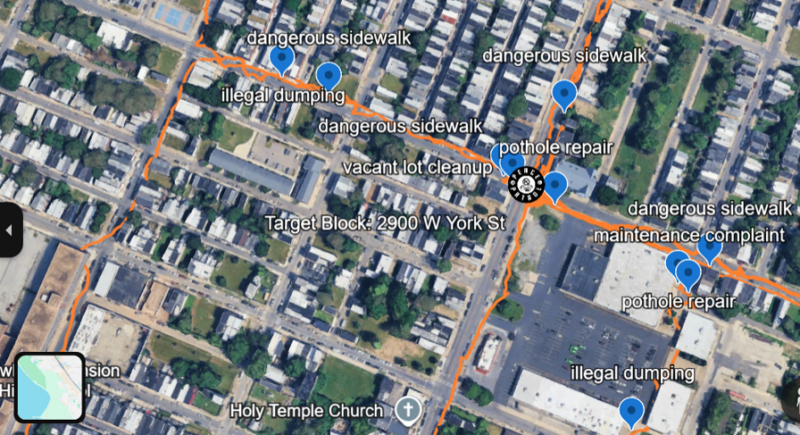
A screenshot of GPS route lines and observation pins captured in the Google Earth application.
Given the data and research that demonstrates the connections between crime and the physical environment, Philly Truce began to think about how the Peace Patrol could extend their impact past the limited patrol hours and also improve the physical environment. So, the Peace Patrol began to use Google Earth to track what Mazzie coined “Lights and Blights.” Using the platform, patrollers could record where Peace Patrollers were and what they saw. Signs of community neglect could be marked with just a few taps and later sent to city agencies or other community groups best equipped to handle them. The Lights & Blight data collection program was implemented not because fixing lights or cleaning an abandoned lot could sweep away years of discriminatory policies, but because it is one direct way that Philly Truce could act to help impacted neighborhoods.
Such community work is often best described as seeing oneself in community and community in oneself, and is central to the work of Philly Truce. The responsibility to others that recognition imparts is central to their mission and the values it wishes to instill in participants, best distilled by the Philly Truce pledge:
“This is my community.
I am responsible for what happens here,
How it looks here and what I do here!”
Google Earth in Action
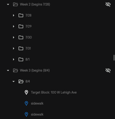
Google Earth Project folder structure used for nightly data collection on Peace Patrol, with weekly and daily folders containing Target Block and observation pins.
Carrying iPads equipped with the Google Earth app, patrollers set out on their hourly patrols lasting from 6:30 PM to 10:30 PM. As they walk their route, Philly Truce collects data on neighborhood blights and records them using Google Earth’s location tools by dropping a pin at their location, then saving it with a title and adding a text description or photo. Each patrol day has its own dated folder in the season’s Google Earth project, pre-loaded with a marker for that night’s target block, along with additional folders containing instructional guides for patrollers and community resource lists. Verbal engagements with community members are counted separately using a clicker and are recorded in a binder at the base. Each night ends with an online Exit Ticket using Google Forms that summarizes blight observations, engagements, and any important incidents. Google Forms automatically places this information into a spreadsheet that Philly Truce and CoLab use to store and analyze data. GPS routes are tracked using the Avenza Maps hiking app, which are then processed up by the CoLab GIS Analyst and added back into the Google Earth project.
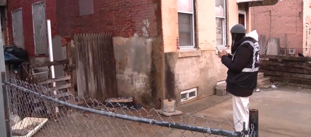
West Philadelphia CoLab Coordinator Christopher Oluwole stands in front of a neighborhood blight, capturing it on his phone using the Google Earth app on the first night of patrol.
In 2025, patrollers labeled ‘blights’ using broad categories created during pilot testing: abandoned vehicles, boarded-up properties, clogged sewers, poor lighting, pests or roadkill, reckless driving, heavy dumping, overgrown grass, and vacant lots. In 2026, these categories were adjusted to match 311 reporting categories, streamlining report submission and making it easier for the city to respond.
Each cohort of participants were given an introductory training by the CoLab GIS & Data Analyst covering Google Earth use, blight identification and collection, and a brief tour of the web and mobile apps. As the process was refined, it became clear that step-by-step hands-on training proved to be the most effective. During training, Mazzie simplified the process of data collection – “Record the blight, Name the blight, Snap a Pic, Get Back,” passing around an iPad for mock data collection until everyone felt confident in the process. Philly Truce’s assigned CoLab coordinator, Christopher Oluwole, would then accompany patrollers on their first few outings to model data collection and help to troubleshoot and reinforce data collection protocols. Patrollers quickly preferred using photos over written descriptions because they were easier to capture and provided more detail. Adept Google Earth users became valuable assets in cross-training their fellow patrollers and future cohorts. Several of these patrollers have returned in 2026, providing key process continuity and intra-team skill sharing that has been integral to the project’s success and sustainability.
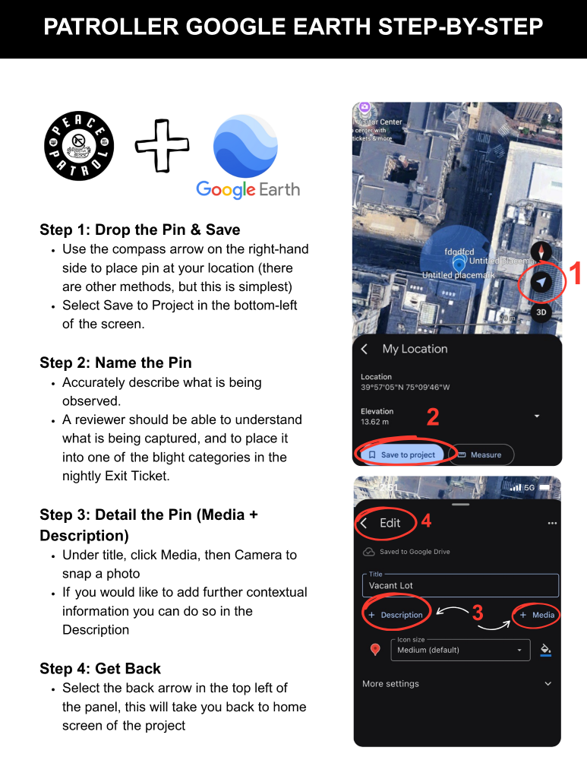
A step-by-step data collection process guide used for patroller onboarding, containing screenshots from the Google Earth mobile app.
Limitations of Google Earth
Google Earth’s impressive capabilities, accessibility, integration with the rest of the Google Suite, and general reliability and ease-of-use affirmed our choice to employ it as the primary tool for Peace Patrol’s Lights & Blight data collection program. Despite this, Google Earth was not without its limitations. For example, blight placemarks logged in Google Earth do not record a timestamp feature and thus are not automatically recorded within the day’s assigned folder. This limitation necessitated additional data protocols to ensure observation pins were manually moved into the appropriate folder before the next day’s patrol to protect from data loss. Even with this manual process, placemarks in Google Earth do not indicate their folder path when exported or viewed directly on the globe, creating downstream issues when trying to view a specific day’s blight data on the virtual globe.
In utilizing Google Earth for the Lights & Blight project, we also encountered several other minor limitations. Google does not provide a version history rollback feature, nor does it allow users to automatically backup Earth projects. This necessitated a weekly manual backup process to ensure data integrity. Additionally, Google Earth also does not allow GPS tracking of walking routes, which required patrollers to use an additional external app, Avenza. While a minor issue, this necessitated a separate intake process to ensure data quality. This limitation led to significant undercounts of year-end miles and block patrol totals, as GPS tracking processes were not solidified until mid-year. Finally, Avenza and other apps that allow for users to place geolocated pins generally allow for the creation of pre-defined attribute drop-down selections when placing features, which would be an incredible benefit to our data collection process were it natively available in Google Earth. Despite these limitations, Google Earth’s benefits greatly outweighed what it lacked, and was overall a great fit for Philly Truce’s Lights & Blight data collection project.
Looking Back & Pushing Forward
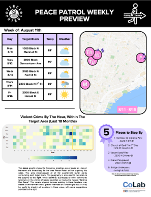
In addition to ongoing data training and analysis, CoLab also synthesized the collected data and compiled it into multiple work products to support Peace Patrol’s weekly reporting and planning. The observations recorded in Google Earth, GPS route information captured in Avenza, and engagement counts were compiled into Weekly Recaps and Previews to be delivered to patrollers. The Recaps (“Looking Back”) provided stats on daily and weekly engagement and observation totals, a breakdown of observations by type, as well as weekly totals of miles walked and equivalent city blocks. The Previews (“Pushing Forward”) contained an hour-by-hour temporal analysis of violent crime in the patrol areas, and a recommendation of “Five Places to Stop By,” using an internal crime analysis, as well as a weekly weather forecast (very much subject to change). Both the Recaps and Previews included mapping created by the CoLab GIS & Data Analyst, accompanied by a table of the week’s target blocks.
Internal surveys of patrollers showed these reports were well received and enriched the program experience. These reports – especially when handed out in physical form – provided a space for reflection, interpretation, and discussion of the weeks that had passed and those to come. Participants could see metrics like “distance walked” increase over time as they became more comfortable in their roles and with the data collection technologies. Weekly maps previewing the target block schedule helped to prepare patrollers for the days ahead.
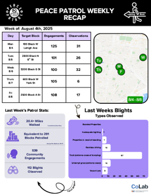
Weekly CoLab produced work product using data collected in Google Earth on Peace Patrol. Contains schedules, observation and engagement totals, weekly summary totals, mapping, and other support materials. Above left: Weekly Recap (“Looking Back”), Above right: Weekly Preview (“Pushing Forward”)
Philly Truce’s Impact
Over the course of 2025, Philly Truce’s Peace Patrol patrolled over 382 miles, the equivalent of 5,456 Philadelphia blocks, and recorded 2,305 observations of Lights & Blight using the Google Earth app, an average of 20 observations per patrol day. The most frequent blights observed, by a significant margin, were broken or dangerous sidewalks, illegal dumping, and abandoned or dilapidated buildings and lots.
In the fall of 2025, Philly Truce partnered with the University of Pennsylvania’s Dr. Lisa Servon and students from her “Community Engagement for Planners, Policy Makers, and Designers” master’s course to conduct an external evaluation of the Google Earth + Peace Patrol program. This partnership strengthened Philly Truce’s work with additional process improvements, such as streamlined reporting of observed blights to 311, to help directly address these community issues. In the winter of 2025, Peace Patrol conducted transit-based operations in collaboration with SEPTA and with technical support from CoLab. These partnerships expanded their reach and deepened their impact in the city. Learn more about Peace Patrol’s impact in this extended data report produced by the DATA CoLab in collaboration with Philly Truce.
The Future of Peace Patrol
2026 has brought many significant developments to Philly Truce and the Google Earth data collection program. The introduction of an improved block identification methodology has strengthened Philly Truce’s data foundations and allowed them to better focus on communities that need their services the most. The development and streamlining of a 311-reporting process has deepened Peace Patrol’s impact long after they are physically on site. Training of patrollers has become more standardized, and along with carryover experience from the year prior, has led to a smoother rollout of data collection in Google Earth.
The DATA CoLab initiative is coming to a close on September 30th, 2026,so over the past few months, CoLab has begun to train on and hand-off more of the data upkeep responsibilities to Philly Truce staff, with an eye toward long-term stability. While the DATA CoLab continues to pursue grant funding to work with community-based organizations in such a great capacity in the future, the DATA Lab is committed to ensuring that the data dashboard offers the public access to criminal legal data.
It is CoLab and Philly Truce’s shared hope that the geographic record of Peace Patrol’s operations and blight observations collected using Google Earth will give researchers the foundation to rigorously assess Peace Patrol’s contribution to neighborhood safety in the years ahead.
Acknowledgements
The DATA CoLab is honored to work with organizations like Philly Truce.
We welcome feedback, comments, and inquiries to collaborate with the CoLab or support for the associated community partners at [email protected].
The DATA CoLab is made possible through funding from the Pennsylvania Commission on Crime and Delinquency (PCCD).
———–
-
i Iadonisi, M. (2021, March 12). “Call a truce”: Philly friends design mobile app to reduce gun violence. 6abc Philadelphia. https://6abc.com/post/timely-violence-shootings-gun/10411788/
-
ii Palmer, C., Purcell, D., Orso, A., Duchneskie, J., & Griffin, J. (2021, September 16). Intersections of Injustice. The Philadelphia Inquirer. https://www.inquirer.com/news/a/philadelphia-shootings-homicides-redlining-kensington-20210916.html
-
iii Ideas We Should Scale Showcase. (2025). The Philadelphia Citizen. https://thephiladelphiacitizen.org/iwsscale/
-
iv Rothstein, R. (2017). The color of law: A forgotten history of how our government segregated America. Liveright Publishing.
-
v Id.
-
vi Shields, M., & Siddique, M. (2020, June 4). The Color of Inequality Part 1: Housing and the Built Environment. Economy League of Greater Philadelphia.
-
vii Sampson, R. J., Raudenbush, S. W., & Earls, F. J. (1997). Neighborhoods and violent crime: A multilevel study of collective efficacy. Science, 277(5328), 918–924. https://doi.org/10.1126/science.277.5328.918
-
viii Id.